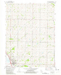
1981 Map of Mound City
USGS Topo · Published 1982About this map
Mound City sits at the base of the loess bluffs in Holt County, where the hills of Benton and Liberty townships meet the flat bottomlands of the Missouri River valley. The landscape is defined by the drainage systems of Squaw Creek and its tributaries, including the Middle Branch and East Branch. To the southwest, the edge of the Squaw Cr National Wildlife Refuge marks a significant transition into the managed wetlands of the flyway.
Find a feature on this map
24 named features on this map. Tap any name to fly to it.
Don’t see what you’re looking for? This feature index may not catch every label — zoom into the map to look around manually.
Map Details
Editions of this 1981 Mound City Map
This is the sole edition of this map. No revisions or reprints were ever made.
Other maps of this area

1920 · Craig
USGS Topo · 1:62,500

1926 · Maitland
USGS Topo · 1:62,500

1939 · Tarkio
USGS Topo · 1:62,500

1939 · Skidmore
USGS Topo · 1:62,500

1940 · Tarkio
USGS Topo · 1:62,500

1941 · Tarkio
USGS Topo · 1:62,500

1941 · Skidmore
USGS Topo · 1:62,500

1942 · Skidmore
USGS Topo · 1:62,500

1955 · Nebraska City
USGS Topo · 1:250,000

1957 · Nebraska City
USGS Topo · 1:250,000