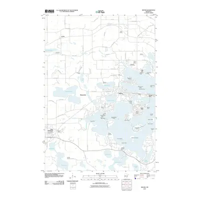
2010 Map of Mound
USGS Topo · Published 2010About this map
Lake Minnetonka dominates the eastern landscape of this 2010 survey, where intricate shorelines create numerous points and islands. In Mound, residential development is clustered around Langdon Lake and the various bays, while to the west, Minnetrista and Saint Bonifacius maintain a more dispersed character. The region is defined by its diverse water bodies, from the expansive Whaletail Lake and Dutch Lake to the smaller Stone Lake and Schutz Lake. The map serves as a vital record for genealogists, documenting several local burial grounds including the Halsted Family Cemetery and German Baptist Cemetery. Unusual aviation features like the Peil-Juliar Seaplane Base on the northern shore and Flobacks Seaplane Base near Eagle Island highlight the importance of the water in local transport and recreation. The Luce Line Trl cuts across the northern section, following a former rail corridor through the landscape near Lyndale.
Find a feature on this map
111 named features on this map. Tap any name to fly to it.
Don’t see what you’re looking for? This feature index may not catch every label — zoom into the map to look around manually.
Map Details
Editions of this 2010 Mound Map
This is the sole edition of this map. No revisions or reprints were ever made.
Other maps of this area

1905 · Minnetonka
USGS Topo · 1:62,500

1907 · Minnetonka
USGS Topo · 1:62,500

1909 · Rockford
USGS Topo · 1:62,500

1953 · Saint Paul
USGS Topo · 1:250,000

1953 · Stillwater
USGS Topo · 1:250,000

1955 · Stillwater
USGS Topo · 1:250,000

1957 · Waconia
USGS Topo · 1:62,500

1958 · Stillwater
USGS Topo · 1:250,000

1958 · Victoria
USGS Topo · 1:24,000

1958 · Rockford
USGS Topo · 1:62,500