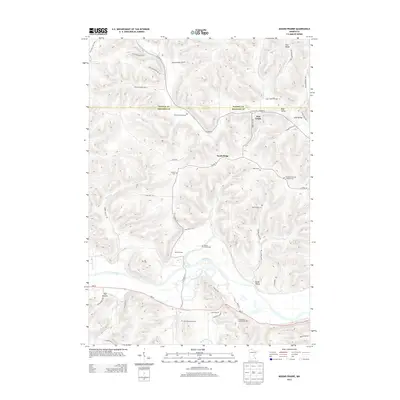
2013 Map of Mound Prairie
USGS Topo · Published 2013About this map
Mound Prairie and the surrounding river bottomlands define this portion of Houston County, where the Root River carves a path through the steep terrain of southeastern Minnesota. The map reveal a landscape deeply tied to family heritage, documented by a high concentration of private burial grounds such as Sheldon Family Cem, Ruff Family Cem, and Fairbanks Family Cem. These sites, along with the Immanuel German Lutheran Cem, reflect the settlement patterns of 19th-century immigrant farming communities. Transportation follows the natural contours of the land, with MN-16 and Co HWY-25 connecting dispersed hamlets like Brush Valley and Pine Creek. From the heights of South Ridge down to the valley floor, the map traces the intricate drainage of Day Cr and Mound Prairie Cr, illustrating the relationship between the regional hydrology and the enduring rural road network.
Find a feature on this map
53 named features on this map. Tap any name to fly to it.
Don’t see what you’re looking for? This feature index may not catch every label — zoom into the map to look around manually.
Map Details
Editions of this 2013 Mound Prairie Map
This is the sole edition of this map. No revisions or reprints were ever made.
Other maps of this area

1930 · La Crescent
USGS Topo · 1:62,500

1956 · Brownsville
USGS Topo · 1:62,500

1956 · La Crescent
USGS Topo · 1:62,500

1958 · Houston
USGS Topo · 1:62,500

1958 · La Crosse
USGS Topo · 1:250,000

1961 · La Crosse
USGS Topo · 1:250,000

1965 · La Crosse
USGS Topo · 1:250,000

1965 · Sheldon
USGS Topo · 1:24,000
1973 · Pickwick
USGS Topo · 1:24,000
1973 · Mound Prairie
USGS Topo · 1:24,000