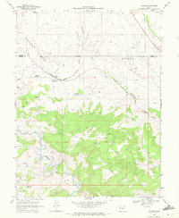
1969 Map of Mounds
USGS Topo · Published 1972About this map
Mounds sits at the intersection of heavy rail and critical water infrastructure along the border of Carbon and Emery Counties in the late 1960s. The Denver and Rio Grande Western railroad tracks dominate the central landscape, passing through Verde and providing a transportation spine for the region. The map highlights a transition from industrial activity to varied terrain, evidenced by the scattered oil wells of the Grassy Trail and Gas Field in the northeast and the distinctive Balanced Rock to the southwest. Water management is a defining characteristic of this arid environment, with numerous man-made features such as Spider Reservoir, Goodwater Reservoir, and an Aqueduct supporting local needs. The meandering course of the Price River cuts through the southern section, while labels like Church Flats and Sage Flat reveal the naming conventions of the high desert topography.
Find a feature on this map
23 named features on this map. Tap any name to fly to it.
Don’t see what you’re looking for? This feature index may not catch every label — zoom into the map to look around manually.
Map Details
Editions of this 1969 Mounds Map
This is the sole edition of this map. No revisions or reprints were ever made.
Other maps of this area

1886 · Price River
USGS Topo · 1:250,000

1896 · Price River
USGS Topo · 1:250,000

1915 · Sunnyside
USGS Topo · 1:62,500

1915 · Wellington
USGS Topo · 1:62,500

1948 · Woodside
USGS Topo · 1:62,500

1949 · Woodside
USGS Topo · 1:62,500

1950 · Woodside
USGS Topo · 1:62,500

1956 · Price
USGS Topo · 1:250,000

1960 · Price
USGS Topo · 1:250,000

1962 · Price
USGS Topo · 1:250,000