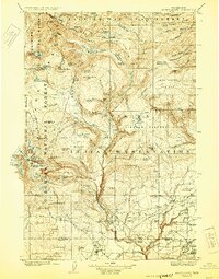
1907 Map of Mount Adams
USGS Topo · Published 1929About this map
Mount Adams and its surrounding glacial peaks dominate this early 20th-century survey of the southern Washington Cascades. The landscape is defined by the massive ice fields of Adams Glacier, Klickitat Glacier, and Mazama Glacier, which feed a complex network of streams like Cispus River and Bird Creek. Beyond the high summits, the map reveals a remote wilderness transitioning into the Yakima Indian Reservation and the Rainier National Forest.
Find a feature on this map
126 named features on this map. Tap any name to fly to it.
Don’t see what you’re looking for? This feature index may not catch every label — zoom into the map to look around manually.
Map Details
Editions of this 1907 Mount Adams Map
5 editions found
Other maps of this area

1899 · Ellensburg
USGS Topo · 1:125,000

1901 · Ellensburg
USGS Topo · 1:125,000

1902 · Mount Aix
USGS Topo · 1:125,000

1904 · Mt Aix
USGS Topo · 1:125,000

1904 · Mount Adams
USGS Topo · 1:125,000

1907 · Mount Adams
USGS Topo · 1:125,000

1924 · Mt Rainier
USGS Topo · 1:96,000

1926 · Steamboat Mtn
USGS Topo · 1:125,000

1926 · Hood River
USGS Topo · 1:125,000

1928 · Mt Rainier
USGS Topo · 1:125,000