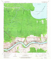
1962 Map of Mount Airy
USGS Topo · Published 1966About this map
San Francisco Plantation and other riverfront estates define the landscape of the early 1960s along this stretch of the Mississippi River. The map captures a transitional river economy where historic sites like Evergreen Plantation and Gold Mine Plantation sit adjacent to industrial developments like the Vacherie Oil and Gas Field. The settlement pattern follows the river's curve, with the communities of Gramercy, Lutcher, and Garyville connected by the Illinois Central Railroad and the Southern Railway. North of the river, the landscape gives way to a complex network of waterways including Blind Bayou and the Amite River Diversion Canal, leading toward the southern reaches of Lake Maurepas. Local genealogists will find value in the specific locations of Woodville Cem, St Joseph Cath Ch, and several neighborhood schools that anchored these riverside parishes.
Find a feature on this map
88 named features on this map. Tap any name to fly to it.
Don’t see what you’re looking for? This feature index may not catch every label — zoom into the map to look around manually.
Map Details
Editions of this 1962 Mount Airy Map
2 editions found
Other maps of this area

1891 · Hahnville
USGS Topo · 1:62,500

1892 · Lac Des Allemands
USGS Topo · 1:62,500

1892 · Mount Airy
USGS Topo · 1:62,500

1892 · Bonnet Carre
USGS Topo · 1:62,500

1892 · Donaldsonville
USGS Topo · 1:62,500

1892 · Thibodaux
USGS Topo · 1:62,500

1932 · Lac Des Allemands NW
USGS Topo · 1:31,680

1932 · Thibodaux NE
USGS Topo · 1:31,680

1932 · Hahnville NW
USGS Topo · 1:31,680

1932 · Lac Des Allemands NE
USGS Topo · 1:31,680