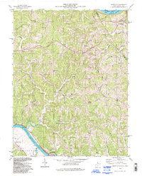
1994 Map of Mount Alto
USGS Topo · Published 1998About this map
The Ohio River and Kanawha River define this corner of Mason County, where the landscape is marked by the steep ridges and deep hollows of the Appalachian Plateau. In the northern reaches, Mount Alto sits near the confluence of Mill Creek and the Ohio, while further south, the Kanawha River winds past Beech Hill and the town of Leon. The map reveals a deeply etched rural social fabric through its numerous small country churches and schools, such as Davies Grove Ch, Mt Olive Ch, and Mountain Flower Sch.
Find a feature on this map
54 named features on this map. Tap any name to fly to it.
Don’t see what you’re looking for? This feature index may not catch every label — zoom into the map to look around manually.
Map Details
Editions of this 1994 Mount Alto Map
This is the sole edition of this map. No revisions or reprints were ever made.
Other maps of this area

1906 · Glenwood
USGS Topo · 1:62,500

1906 · Winfield
USGS Topo · 1:62,500

1908 · Glenwood
USGS Topo · 1:62,500

1908 · Winfield
USGS Topo · 1:62,500

1908 · Ravenswood
USGS Topo · 1:62,500

1908 · Point Pleasant
USGS Topo · 1:62,500

1926 · Ravenswood
USGS Topo · 1:62,500

1926 · Point Pleasant
USGS Topo · 1:62,500

1928 · Ravenswood
USGS Topo · 1:62,500

1929 · Point Pleasant
USGS Topo · 1:62,500