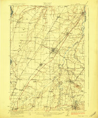
1923 Map of Mount Angel
USGS Topo · Published 1923About this map
Pudding River meanders through the heart of the Willamette Valley in this early 1920s record, defining a landscape defined by its fertile agricultural prairies and a dense network of early rail transit. The map documents the critical intersection of the Southern Pacific Railroad and the Oregon Electric Railway, which fueled the growth of towns like Woodburn, Gervais, and Hubbard. Along the northern edge, the site of Champoeg stands as a point of deep historical significance near the Willamette River.
Find a feature on this map
69 named features on this map. Tap any name to fly to it.
Don’t see what you’re looking for? This feature index may not catch every label — zoom into the map to look around manually.
Map Details
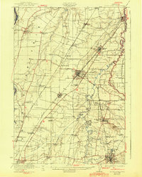
Editions of this 1923 Mount Angel Map
3 editions found
Other maps of this area

1914 · Oregon City
USGS Topo · 1:62,500

1915 · Eola
USGS Topo · 1:31,680

1916 · Tualatin
USGS Topo · 1:62,500

1917 · Salem
USGS Topo · 1:62,500

1923 · Mount Angel
USGS Topo · 1:62,500

1924 · Mc Minnville
USGS Topo · 1:48,000

1925 · Stayton
USGS Topo · 1:62,500

1926 · Mc Minnville
USGS Topo · 1:62,500

1939 · Molalla
USGS Topo · 1:62,500

1939 · Oregon City
USGS Topo · 1:62,500