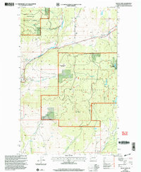
2001 Map of Mount Annie
USGS Topo · Published 2004About this map
Wauconda sits along the northern edge of this high-elevation terrain in the early 2000s, serving as a focal point for the surrounding mountainous landscape. The area is heavily defined by the boundaries of the Okanogan National Forest, which encompasses prominent peaks such as Mount Annie and Little Bonaparte Mountain. Water resources are abundant throughout the quadrangle, with Bonaparte Creek and its tributary Little Bonaparte Creek carving through the valleys, while high meadows like Suttons Meadow and the open Bigham Flat offer localized breaks in the timbered slopes. Evidence of rural life and land use is present in the small Cem (cemetery) located near the northern border and a Gravel Pit near the creek. The complex drainage network, including Cape Labelle Creek and Sourdough Creek, highlights the importance of watershed management in this portion of the Pacific Northwest.
Find a feature on this map
18 named features on this map. Tap any name to fly to it.
Don’t see what you’re looking for? This feature index may not catch every label — zoom into the map to look around manually.
Map Details
Editions of this 2001 Mount Annie Map
This is the sole edition of this map. No revisions or reprints were ever made.
Other maps of this area

1902 · Osoyoos
USGS Topo · 1:125,000

1904 · Osoyoos
USGS Topo · 1:125,000

1904 · Republic
USGS Topo · 1:125,000

1951 · Wauconda
USGS Topo · 1:62,500

1951 · Bodie Mountain
USGS Topo · 1:62,500

1954 · Okanogan
USGS Topo · 1:250,000

1957 · Mt. Bonaparte
USGS Topo · 1:62,500

1957 · Aeneas Valley
USGS Topo · 1:62,500

1958 · Okanogan
USGS Topo · 1:250,000

1958 · Aeneas
USGS Topo · 1:62,500