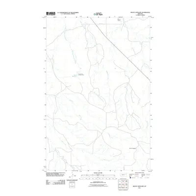
2011 Map of Mount Antelope
USGS Topo · Published 2011About this map
Mount Antelope rises above a landscape defined by an intricate network of drainage systems and early 21st-century water management projects. This McCone County survey highlights the hydraulic importance of the Buffalo Springs Creek and its western fork, as well as the notable branching of Hell Creek and McCune Creek. The terrain is punctuated by small-scale reservoirs and dams, specifically Quick Reservoir, which is supported by the Floyd Quick Number 2 Dam, and the northern Voss Number 1 Dam. These features illustrate the ranching or agricultural infrastructure required to manage water in this part of Montana. Transportation in the area remains sparse, anchored primarily by Road 201 and Wittkopp Rd, reflecting the remote character of the territory near Deep Bottom.
Find a feature on this map
12 named features on this map. Tap any name to fly to it.
Don’t see what you’re looking for? This feature index may not catch every label — zoom into the map to look around manually.
Map Details
Editions of this 2011 Mount Antelope Map
This is the sole edition of this map. No revisions or reprints were ever made.
Other maps of this area

1954 · Glendive
USGS Topo · 1:250,000

1957 · Glendive
USGS Topo · 1:250,000

1958 · Glendive
USGS Topo · 1:250,000

1982 · Circle
USGS Topo · 1:100,000
1983 · Union School
USGS Topo · 1:24,000

1983 · Woodworth Hill
USGS Topo · 1:24,000

1983 · Olson Coulee South
USGS Topo · 1:24,000

1983 · Mount Antelope
USGS Topo · 1:24,000

1983 · Quick Reservoir
USGS Topo · 1:24,000

1983 · Circle
USGS Topo · 1:24,000