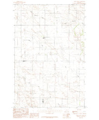
1983 Map of Union School
USGS Topo · Published 1983About this map
Union School stands as a focal point of this rural landscape in the early 1980s, marking a central community landmark where the high plains of Eastern Montana meet the winding drainages of the Dawson and Prairie county line. The terrain is defined by the intricate erosion patterns of the Upper Sevenmile Creek system to the north and the expansive reach of Clear Creek to the south. This 1983 provisional survey captures the transition between these two watersheds, showing the sparse network of ranch roads and section lines that structured life in this semi-arid region. The presence of the South Fork Clear Creek further illustrates the complex hydrological layout that influenced grazing patterns and early homesteading efforts along these intermittent waterways. This document is a precise record of the administrative and educational infrastructure supporting the remote agricultural families near the county border.
Find a feature on this map
6 named features on this map. Tap any name to fly to it.
Don’t see what you’re looking for? This feature index may not catch every label — zoom into the map to look around manually.
Map Details
Editions of this 1983 Union School Map
This is the sole edition of this map. No revisions or reprints were ever made.
Other maps of this area

1954 · Glendive
USGS Topo · 1:250,000

1957 · Glendive
USGS Topo · 1:250,000

1958 · Glendive
USGS Topo · 1:250,000

1982 · Circle
USGS Topo · 1:100,000
1983 · Lindsay SW
USGS Topo · 1:24,000
1983 · North Coulee
USGS Topo · 1:24,000

1983 · Olson Coulee South
USGS Topo · 1:24,000

1983 · Mount Antelope
USGS Topo · 1:24,000

1983 · Deer Creek Church
USGS Topo · 1:24,000
1983 · Diamond G Butte
USGS Topo · 1:24,000