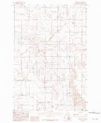
1983 Map of Lindsay SW
USGS Topo · Published 1983About this map
South Fork Clear Creek and the main branch of Clear Creek carve through the high plains of Dawson County in this early 1980s provisional survey. The landscape is defined by the headwaters of several drainage systems, including the uniquely named Bad Route Creek and Cracker Box Creek, which flow toward the lower elevations at the edge of the quadrangle. Human presence is sparse but centered on rural infrastructure and education, with Union School and Upper Cracker Box School serving the scattered ranching community. The mapping of Storage Bins suggests a localized agricultural focus, likely grain or livestock feed, supported by the network of unimproved roads and trails that traverse the terrain between the Middle Fork and East Fork tributaries. This map provides a look at eastern Montana ranch country before the widespread consolidation of small rural school districts.
Find a feature on this map
10 named features on this map. Tap any name to fly to it.
Don’t see what you’re looking for? This feature index may not catch every label — zoom into the map to look around manually.
Map Details
Editions of this 1983 Lindsay SW Map
This is the sole edition of this map. No revisions or reprints were ever made.
Other maps of this area

1953 · Miles City
USGS Topo · 1:250,000

1954 · Glendive
USGS Topo · 1:250,000

1957 · Miles City
USGS Topo · 1:250,000

1957 · Glendive
USGS Topo · 1:250,000

1958 · Miles City
USGS Topo · 1:250,000

1958 · Glendive
USGS Topo · 1:250,000
1967 · Fallon NE
USGS Topo · 1:24,000

1972 · Hendrickson Coulee
USGS Topo · 1:24,000

1972 · Diamond G Creek
USGS Topo · 1:24,000

1980 · Terry
USGS Topo · 1:100,000