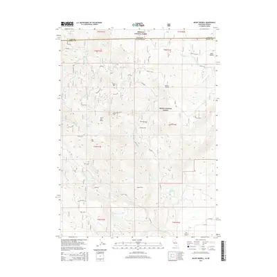
2015 Map of Mount Bidwell
USGS Topo · Published 2015About this map
Mount Bidwell dominates this high-altitude landscape along the border of California and Oregon, marking a rugged intersection within the Fremont National Forest and Modoc National Forest. The 2015 survey reveals a legacy of resource extraction, with the Morrell Mine and scattered Old Mines dotting the terrain near the Highgrade district. This area is characterized by high alpine water bodies like Lily Lake, Rock Lake, and the curiously named Poison Lake, alongside significant wetlands such as the Dismal Swamp. The presence of the Fort Bidwell Airport to the south indicates the region's connection to the larger Surprise Valley, while numerous forest service spurs and county roads like Co Road 2 provide access to remote flats such as O'Connors Flat and Coyote Flat. The map also notes a dedicated Reservation area, highlighting the complex land management between national forest, tribal, and private boundaries.
Find a feature on this map
59 named features on this map. Tap any name to fly to it.
Don’t see what you’re looking for? This feature index may not catch every label — zoom into the map to look around manually.
Map Details
Editions of this 2015 Mount Bidwell Map
This is the sole edition of this map. No revisions or reprints were ever made.
Other maps of this area

1886 · Alturas
USGS Topo · 1:250,000

1892 · Alturas
USGS Topo · 1:250,000

1954 · Alturas
USGS Topo · 1:250,000

1955 · Klamath Falls
USGS Topo · 1:250,000

1958 · Alturas
USGS Topo · 1:250,000

1958 · Klamath Falls
USGS Topo · 1:250,000

1962 · Alturas
USGS Topo · 1:250,000

1962 · Willow Ranch
USGS Topo · 1:62,500

1962 · Fort Bidwell
USGS Topo · 1:62,500
1964 · Crane Creek
USGS Topo · 1:24,000