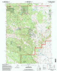
1993 Map of Mount Bidwell
USGS Topo · Published 1996About this map
The Warner Mountains dominate this 1990s landscape at the intersection of California and Oregon, where high-altitude mining and rugged topography meet the northern reaches of the Surprise Valley. The map highlights a significant legacy of extraction within the Modoc National Forest, documenting numerous industrial sites such as the Modoc Mines, Sunshine Mine, and Brite Belt Mine. This concentration of prospects and pits, particularly around Yellow Mountain, suggests a landscape shaped by persistent mineral exploration across the 20th century.
Find a feature on this map
50 named features on this map. Tap any name to fly to it.
Don’t see what you’re looking for? This feature index may not catch every label — zoom into the map to look around manually.
Map Details
Editions of this 1993 Mount Bidwell Map
This is the sole edition of this map. No revisions or reprints were ever made.
Other maps of this area

1886 · Alturas
USGS Topo · 1:250,000

1892 · Alturas
USGS Topo · 1:250,000

1954 · Alturas
USGS Topo · 1:250,000

1955 · Klamath Falls
USGS Topo · 1:250,000

1958 · Alturas
USGS Topo · 1:250,000

1958 · Klamath Falls
USGS Topo · 1:250,000

1962 · Alturas
USGS Topo · 1:250,000

1962 · Willow Ranch
USGS Topo · 1:62,500

1962 · Fort Bidwell
USGS Topo · 1:62,500
1964 · Crane Creek
USGS Topo · 1:24,000