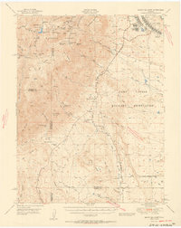
1951 Map of Mount Big Chief
USGS Topo · Published 1951About this map
Pike National Forest dominates the high country west of Colorado Springs, where peaks like Mount Big Chief and Mount Vigil tower over a landscape of steep gulches and mountain camps. This early 1950s survey captures the transition from wilderness and agricultural ranching to significant military infrastructure, notably the expansive Camp Carson Military Reservation. Within the reservation, specialized facilities such as the Camp Carson Hospital and a Rifle Range are clearly mapped. The rugged terrain is punctuated by historical homesteads and mountain retreats, including Emerald Valley Ranch, Hitch Rack Ranch, and Turkey Creek Ranch. Educational life in the more remote canyons is marked by the presence of Lytle School and Red Creek School, while the Gold Camp Road provides a primary transit corridor through the foothills. The map reveals a complex water system including the Penrose-Rosemont Reservoir and numerous creeks like Little Fountain Creek that drain toward the plains.
Find a feature on this map
71 named features on this map. Tap any name to fly to it.
Don’t see what you’re looking for? This feature index may not catch every label — zoom into the map to look around manually.
Map Details
Editions of this 1951 Mount Big Chief Map
2 editions found
Other maps of this area

1889 · Canon City
USGS Topo · 1:125,000

1891 · Pueblo
USGS Topo · 1:125,000

1892 · Canon City
USGS Topo · 1:125,000

1893 · Colorado Springs
USGS Topo · 1:125,000

1894 · Pikes Peak
USGS Topo · 1:125,000

1894 · Pueblo
USGS Topo · 1:125,000

1896 · Pueblo
USGS Topo · 1:125,000

1897 · Pueblo
USGS Topo · 1:125,000

1901 · Pikes Peak
USGS Topo · 1:125,000

1901 · Pikes Peak
USGS Topo · 1:62,500