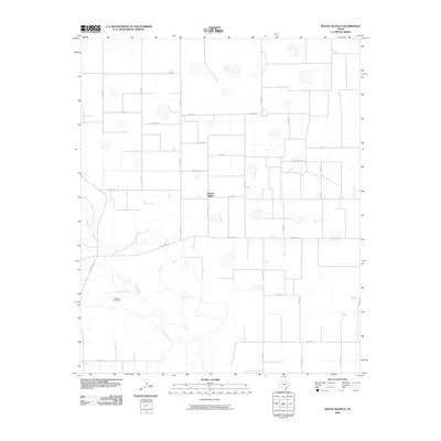
2010 Map of Mount Blanco
USGS Topo · Published 2010About this map
Mount Blanco sits atop the high plains of the Texas Panhandle, anchoring a grid-defined landscape of agricultural ranch roads and natural drainage systems. The White River carves a winding path through the southwest corner of the territory, joined by the tributary waters of Crawfish Creek. This environment is shaped by both its hydrology and the necessary infrastructure of West Texas ranching, as evidenced by the isolated Meadow Windmill located near the riverbank. The map reveals a strictly organized network of county roads, including Co RD 211 and Co RD 332, which segment the terrain into a sprawling lattice. The transition from the flat tableland to the more broken geography near the river valley illustrates the subtle shifts in elevation that define the Caprock region, where the intersection of Ranch Rd 193 and Ranch Rd 651 serves as a primary transit corridor for this sparsely populated ranching country.
Find a feature on this map
33 named features on this map. Tap any name to fly to it.
Don’t see what you’re looking for? This feature index may not catch every label — zoom into the map to look around manually.
Map Details
Editions of this 2010 Mount Blanco Map
This is the sole edition of this map. No revisions or reprints were ever made.
Other maps of this area

1954 · Lubbock
USGS Topo · 1:250,000

1965 · Floydada
USGS Topo · 1:24,000

1965 · Floydada SE
USGS Topo · 1:24,000

1965 · Wake
USGS Topo · 1:24,000

1965 · Boothe
USGS Topo · 1:24,000

1966 · Crosbyton
USGS Topo · 1:24,000

1966 · Mount Blanco
USGS Topo · 1:24,000

1966 · McAdoo
USGS Topo · 1:24,000

1967 · Ralls NE
USGS Topo · 1:24,000
1968 · Dougherty
USGS Topo · 1:24,000