
1965 Map of Floydada
USGS Topo · Published 1968About this map
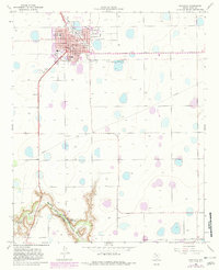
Floydada serves as the focal point of this West Texas landscape, where the street grid is punctuated by community anchors like the Peoples Hospital, Eagles Hall Park, and Napoleon Park. Educational institutions of the mid-1960s are well-represented, including the Andrews Ward Sch and the more distant Della Plain Sch. To the southwest, the terrain shifts dramatically as the flat plains give way to the carved landscape of Blanco Canyon, where the Blanco River and White River converge near several Claypit operations. Transport and utility infrastructure define the area's development, evidenced by the At&Sf railroad lines, a localized Landing Strip, and a Drive-in Theater situated on the western edge of town. Smaller settlements and gathering points like Dada, Lakeview, and the Floydada Country Club reflect the social and agricultural distribution of Floyd County during this era.
Find a feature on this map
32 named features on this map. Tap any name to fly to it.
Don’t see what you’re looking for? This feature index may not catch every label — zoom into the map to look around manually.
Map Details
Editions of this 1965 Floydada Map
2 editions found
Other maps of this area

1954 · Lubbock
USGS Topo · 1:250,000

1954 · Plainview
USGS Topo · 1:250,000

1958 · Plainview
USGS Topo · 1:250,000

1965 · Lockney SE
USGS Topo · 1:24,000

1965 · Cone
USGS Topo · 1:24,000

1965 · Lockney
USGS Topo · 1:24,000

1965 · Floydada SE
USGS Topo · 1:24,000

1965 · Boothe
USGS Topo · 1:24,000

1965 · Sandhill
USGS Topo · 1:24,000

1966 · Lockney 4 SW
USGS Topo · 1:24,000