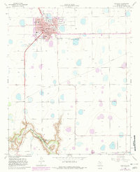
1965 Map of Floydada
USGS Topo · Published 1982About this map
Floydada serves as the focal point of this High Plains survey, showcasing a developed municipal grid characterized by its educational and civic infrastructure. The town's layout includes several local landmarks such as Peoples Hospital, Andrews Ward Sch, and Della Plain Sch. To the south, the terrain shifts dramatically as the flat plateau gives way to the deep incisions of Blanco Canyon, where the White Blanco River carves through the landscape. This area is marked by industrial activity, specifically several Claypits and a Claypit near the canyon rim.
Find a feature on this map
26 named features on this map. Tap any name to fly to it.
Don’t see what you’re looking for? This feature index may not catch every label — zoom into the map to look around manually.
Map Details
Editions of this 1965 Floydada Map
2 editions found
Other maps of this area

1954 · Lubbock
USGS Topo · 1:250,000

1954 · Plainview
USGS Topo · 1:250,000

1958 · Plainview
USGS Topo · 1:250,000

1965 · Lockney SE
USGS Topo · 1:24,000

1965 · Cone
USGS Topo · 1:24,000

1965 · Floydada
USGS Topo · 1:24,000

1965 · Lockney
USGS Topo · 1:24,000

1965 · Floydada SE
USGS Topo · 1:24,000

1965 · Boothe
USGS Topo · 1:24,000

1965 · Sandhill
USGS Topo · 1:24,000