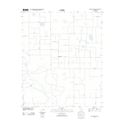
2012 Map of Mount Blanco
USGS Topo · Published 2012About this map
Mount Blanco sits atop the High Plains of Crosby County, where the agricultural grid meets the drainage systems of the Llano Estacado. This 2012 survey shows a landscape defined by expansive ranching and farming operations, bisected by a network of county roads. The most prominent natural feature is the White River, which winds through the southern and western portions of the quadrangle, joined by Crawfish Cr as it carves through the terrain. A sparse collection of landmarks, such as the Meadow Windmill, highlights the critical importance of water management in this semi-arid region. The map captures the infrastructure of rural Texas, including Fm-651 and Ranch Road 1958, which provide essential transit between the widely spaced homesteads and fields that characterize this portion of the Texas Panhandle.
Find a feature on this map
38 named features on this map. Tap any name to fly to it.
Don’t see what you’re looking for? This feature index may not catch every label — zoom into the map to look around manually.
Map Details
Editions of this 2012 Mount Blanco Map
This is the sole edition of this map. No revisions or reprints were ever made.
Other maps of this area

1954 · Lubbock
USGS Topo · 1:250,000

1965 · Floydada
USGS Topo · 1:24,000

1965 · Floydada SE
USGS Topo · 1:24,000

1965 · Wake
USGS Topo · 1:24,000

1965 · Boothe
USGS Topo · 1:24,000

1966 · Crosbyton
USGS Topo · 1:24,000

1966 · Mount Blanco
USGS Topo · 1:24,000

1966 · McAdoo
USGS Topo · 1:24,000

1967 · Ralls NE
USGS Topo · 1:24,000
1968 · Dougherty
USGS Topo · 1:24,000