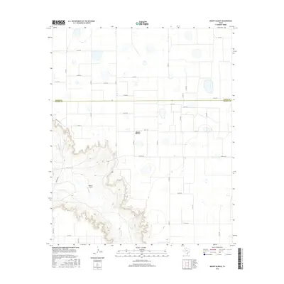
2016 Map of Mount Blanco
USGS Topo · Published 2016About this map
Mount Blanco sits atop the high plains of the Texas Panhandle, marking a transition between the flat agricultural lands and the dramatic breaks of the Caprock. The terrain is defined by the deep incision of Blanco Canyon, where the White River and its tributary, Crawfish Cr, have carved through the landscape. This sharp topographical contrast separates the orderly grid of county roads in Floyd and Crosby counties from the winding contours of the canyon floor. The map illustrates a rural environment shaped by ranching and wide-open spaces, with Ranch Rd 193 and Ranch Rd 651 providing primary access through the broken country. For genealogists and local historians, the proximity of the community to these natural watercourses and the established boundary between Floyd and Crosby counties offers a clear view of the area's geography in the early 21st century.
Find a feature on this map
35 named features on this map. Tap any name to fly to it.
Don’t see what you’re looking for? This feature index may not catch every label — zoom into the map to look around manually.
Map Details
Editions of this 2016 Mount Blanco Map
This is the sole edition of this map. No revisions or reprints were ever made.
Other maps of this area

1954 · Lubbock
USGS Topo · 1:250,000

1965 · Floydada
USGS Topo · 1:24,000

1965 · Floydada SE
USGS Topo · 1:24,000

1965 · Wake
USGS Topo · 1:24,000

1965 · Boothe
USGS Topo · 1:24,000

1966 · Crosbyton
USGS Topo · 1:24,000

1966 · Mount Blanco
USGS Topo · 1:24,000

1966 · McAdoo
USGS Topo · 1:24,000

1967 · Ralls NE
USGS Topo · 1:24,000
1968 · Dougherty
USGS Topo · 1:24,000