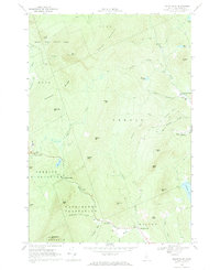
1968 Map of Mount Blue
USGS Topo · Published 1970About this map
Mount Blue State Park dominates the northwest corner of this Franklin County landscape, centered on the towering peaks of Mount Blue and Spruce Mountain. The terrain is defined by steep ridgelines like Gammon Ridge and numerous small water bodies, including Hills Pond and Holman Pond. Settled areas are concentrated in the low-lying intervals where streams like Temple Stream and Wilson Stream provide more level ground. In these pockets, small communities such as Temple Intervale and Wilton Intervale developed around the local watercourses. Historical industry and infrastructure are noted at Hildreths Mill and the Twin Bridges crossing, while family-named features like Gus Mitchell Brook and Henry Mitchell Bk hint at the area's agricultural and homesteading genealogy. The map also identifies the boundaries of Perkins Plantation and Washington Plantation, reflecting the distinct political organization of rural Maine.
Find a feature on this map
51 named features on this map. Tap any name to fly to it.
Don’t see what you’re looking for? This feature index may not catch every label — zoom into the map to look around manually.
Map Details
Editions of this 1968 Mount Blue Map
2 editions found
Other maps of this area

1924 · Farmington
USGS Topo · 1:62,500

1926 · Dixfield
USGS Topo · 1:62,500

1929 · Phillips
USGS Topo · 1:48,000

1929 · Dixfield
USGS Topo · 1:62,500

1930 · Kingfield
USGS Topo · 1:48,000

1932 · Phillips
USGS Topo · 1:62,500

1932 · Kingfield
USGS Topo · 1:62,500

1950 · Lewiston
USGS Topo · 1:250,000

1956 · Dixfield
USGS Topo · 1:48,000

1956 · Farmington
USGS Topo · 1:62,500