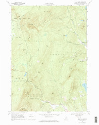
1968 Map of Mount Blue
USGS Topo · Published 1970About this map
Mount Blue State Park dominates the northwest corner of this late-1960s landscape, centered on the heights of Mount Blue and the Lookout Tower that surveys the surrounding Franklin County wilderness. The map reveals a transition from high ridges like Spruce Mountain and Gammon Ridge to the more developed lowlands of Temple and Wilton. Small pockets of settlement and industry are evident at Hildreths Mill and the flatlands of Temple Intervale, where Temple Stream and Mitchell Brook converge.
Find a feature on this map
60 named features on this map. Tap any name to fly to it.
Don’t see what you’re looking for? This feature index may not catch every label — zoom into the map to look around manually.
Map Details
Editions of this 1968 Mount Blue Map
2 editions found
Other maps of this area

1924 · Farmington
USGS Topo · 1:62,500

1926 · Dixfield
USGS Topo · 1:62,500

1929 · Phillips
USGS Topo · 1:48,000

1929 · Dixfield
USGS Topo · 1:62,500

1930 · Kingfield
USGS Topo · 1:48,000

1932 · Phillips
USGS Topo · 1:62,500

1932 · Kingfield
USGS Topo · 1:62,500

1950 · Lewiston
USGS Topo · 1:250,000

1956 · Dixfield
USGS Topo · 1:48,000

1956 · Farmington
USGS Topo · 1:62,500