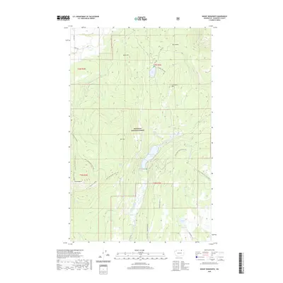
2020 Map of Mount Bonaparte
USGS Topo · Published 2020About this map
Mt Bonaparte and the surrounding high country of the Okanogan National Forest dominate this topography near the Canadian border. The landscape is defined by massive peaks and the drainage basins of Myers Cr and Bonaparte Cr. Significant recreational and natural landmarks are visible, including Bonaparte Lake and the high-elevation Strawberry Mountain. A major segment of the Pacific NW National Scenic Trail winds through the terrain, crossing 4th Of July Ridge and passing near Duff Spring. The map documents a network of forest roads such as Bonaparte Run Rd and Northern Run Rd, which provide access to remote reaches like Box Canyon and Walker Lake. This 2020 survey captures the modern state of these public lands, showing the intersection of natural water features and the specialized infrastructure required to manage these forested highlands.
Find a feature on this map
34 named features on this map. Tap any name to fly to it.
Don’t see what you’re looking for? This feature index may not catch every label — zoom into the map to look around manually.
Map Details
Editions of this 2020 Mount Bonaparte Map
This is the sole edition of this map. No revisions or reprints were ever made.
Other maps of this area

1902 · Osoyoos
USGS Topo · 1:125,000

1904 · Osoyoos
USGS Topo · 1:125,000

1904 · Republic
USGS Topo · 1:125,000

1951 · Wauconda
USGS Topo · 1:62,500

1951 · Bodie Mountain
USGS Topo · 1:62,500

1954 · Okanogan
USGS Topo · 1:250,000

1957 · Mt. Bonaparte
USGS Topo · 1:62,500

1957 · Aeneas Valley
USGS Topo · 1:62,500

1958 · Okanogan
USGS Topo · 1:250,000

1958 · Aeneas
USGS Topo · 1:62,500