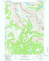
1981 Map of Mount Bonneville
USGS Topo · Published 1982About this map
The Continental Divide defines the crest of this high-altitude landscape, separating the headwaters of the East Fork River from the drainages of the Shoshone National Forest. This 1981 survey of the Wind River Range shows the alpine geography of the Bridger Wilderness at a time when its footpaths were already well-established. Glacial activity is evident in features like Hooker Glacier tucked beneath Mount Hooker, and the numerous tarns including Grave Lake and the Bonneville Lakes.
Find a feature on this map
50 named features on this map. Tap any name to fly to it.
Don’t see what you’re looking for? This feature index may not catch every label — zoom into the map to look around manually.
Map Details
Editions of this 1981 Mount Bonneville Map
3 editions found
Other maps of this area

1937 · Moccasin Lake
USGS Topo · 1:48,000

1938 · Mt Bonneville
USGS Topo · 1:62,500

1941 · Mt Bonneville
USGS Topo · 1:62,500

1942 · Mt Bonneville
USGS Topo · 1:62,500

1943 · Moccasin Lake
USGS Topo · 1:62,500

1955 · Lander
USGS Topo · 1:250,000

1958 · Lander
USGS Topo · 1:250,000

1961 · Lander
USGS Topo · 1:250,000

1969 · Pocket Creek Lake
USGS Topo · 1:24,000
1969 · Big Sandy Opening
USGS Topo · 1:24,000