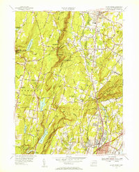
1954 Map of Mount Carmel
USGS Topo · Published 1956About this map
Sleeping Giant State Park dominates the eastern topography of this mid-century landscape, providing a clear view of the transition from industrial corridors to protected New England forests. The New York New Haven and Hartford Railroad and the Quinnipiac River cut through the central valley, while the western hills are defined by the Naugatuck State Forest and a series of critical reservoirs including Lake Watrous, Lake Chamberlain, and Lake Dawson.
Find a feature on this map
67 named features on this map. Tap any name to fly to it.
Don’t see what you’re looking for? This feature index may not catch every label — zoom into the map to look around manually.
Map Details
Editions of this 1954 Mount Carmel Map
3 editions found
Other maps of this area

1889 · Derby
USGS Topo · 1:62,500

1891 · Derby
USGS Topo · 1:62,500

1892 · New Haven
USGS Topo · 1:62,500

1892 · Meriden
USGS Topo · 1:62,500

1893 · Waterbury
USGS Topo · 1:62,500

1893 · Meriden
USGS Topo · 1:62,500

1893 · Derby
USGS Topo · 1:62,500

1904 · Waterbury
USGS Topo · 1:62,500

1904 · Litchfield
USGS Topo · 1:125,000

1906 · Farmington
USGS Topo · 1:125,000