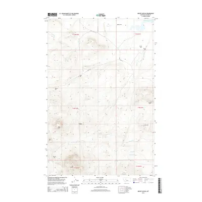
2014 Map of Mount Cecelia
USGS Topo · Published 2014About this map
Mt Cecelia anchors this high-elevation landscape in the foothills of the Big Belt Mountains, where several prominent buttes and peaks define the horizon. The terrain is marked by a series of named rises including Cascade Butte, Johnson Butte, and Skull Butte, providing a detailed look at the topographic profile of this area south of the Missouri River. A network of creeks, such as Hunters Cr, Lepley Cr, and Saint Johns Cr, drain the high ground, while Rocky Reef Reservoir and Muddy Flats sit in the northern reaches. This 2014 survey documents the existing road infrastructure through the mountain passes, including Simms Cascade Rd and Mission Rd, which connect the scattered high-country landmarks. The map offers researchers clear identification of family-named or locally significant terrain features like Warner Hill, Dime Hill, and Wolf Point, alongside the expansive grazing lands of Antelope Flat.
Find a feature on this map
30 named features on this map. Tap any name to fly to it.
Don’t see what you’re looking for? This feature index may not catch every label — zoom into the map to look around manually.
Map Details
Editions of this 2014 Mount Cecelia Map
This is the sole edition of this map. No revisions or reprints were ever made.
Other maps of this area

1886 · Great Falls
USGS Topo · 1:250,000

1949 · Cascade
USGS Topo · 1:62,500

1951 · Cascade
USGS Topo · 1:62,500

1954 · Great Falls
USGS Topo · 1:250,000

1957 · Great Falls
USGS Topo · 1:250,000

1960 · Simms
USGS Topo · 1:62,500

1961 · Hardy
USGS Topo · 1:24,000

1961 · Rocky Reef
USGS Topo · 1:24,000
1961 · Mid Canon
USGS Topo · 1:24,000
1976 · Great Falls South
USGS Topo · 1:100,000