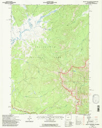
1991 Map of Mount Chittenden
USGS Topo · Published 1997About this map
The Pelican Valley dominates this high-country landscape, where geothermal activity and alpine watersheds converge. The presence of multiple Thermal Areas near Pelican Creek and Pelican Springs highlights the unique geology of this portion of Yellowstone National Park. This 1991 revision provides a clear record of the backcountry infrastructure of the era, specifically the isolated Pelican Springs Cabin and the system of footpaths crossing Mist Creek Pass and Jones Pass. The boundary of the North Absaroka Wilderness and Shoshone National Forest is defined by the high peaks, including Mount Chittenden. This terrain is further articulated by numerous watercourses such as Raven Creek, Astringent Creek, and the headwaters of Jones Creek near Stonecup Lake, showing the intricate drainage patterns of the Absaroka Range before the turn of the 21st century.
Find a feature on this map
25 named features on this map. Tap any name to fly to it.
Don’t see what you’re looking for? This feature index may not catch every label — zoom into the map to look around manually.
Map Details
Editions of this 1991 Mount Chittenden Map
This is the sole edition of this map. No revisions or reprints were ever made.
Other maps of this area

1885 · Lake
USGS Topo · 1:125,000

1886 · Canyon
USGS Topo · 1:125,000

1895 · Canyon
USGS Topo · 1:125,000

1895 · Lake
USGS Topo · 1:125,000

1896 · Lake
USGS Topo · 1:125,000

1896 · Canyon
USGS Topo · 1:125,000

1901 · Canyon
USGS Topo · 1:125,000

1901 · Lake
USGS Topo · 1:125,000

1906 · Lake
USGS Topo · 1:125,000

1907 · Canyon
USGS Topo · 1:125,000