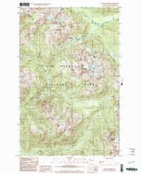
1999 Map of Mount Christie
USGS Topo · Published 2003About this map
Olympic National Park defines this landscape, centered on the high divide where the Elwha River and the North Fork Quinault River systems originate. The terrain is marked by significant summits including Mount Christie, Mount Noyes, and Mount Seattle, creating a dramatic vertical environment. Human presence is limited to backcountry infrastructure that supports wilderness navigation, notably the Low Divide Ranger Station and isolated outposts like Chicago Camp and Twelvemile Shelter. The hydrologic pattern is intricate, with high-altitude basins holding Lake Mary, Lake Margaret, and Martins Lakes. This provisional survey documents the drainage network of Geoduck Creek and Rustler Creek as they feed the primary river valleys, providing a precise record of the trail-accessible interior before modern digital shifts.
Find a feature on this map
23 named features on this map. Tap any name to fly to it.
Don’t see what you’re looking for? This feature index may not catch every label — zoom into the map to look around manually.
Map Details
Editions of this 1999 Mount Christie Map
This is the sole edition of this map. No revisions or reprints were ever made.
Other maps of this area

1935 · Mount Olympus
USGS Topo · 1:62,500

1938 · Mt Constance
USGS Topo · 1:125,000

1942 · Mount Olympus
USGS Topo · 1:62,500

1944 · Mt. Angeles
USGS Topo · 1:62,500

1946 · Mt. Angeles
USGS Topo · 1:62,500

1947 · Mt. Steel
USGS Topo · 1:62,500

1947 · Mt Christie
USGS Topo · 1:62,500

1950 · Mt Christie
USGS Topo · 1:62,500

1950 · Mt. Steel
USGS Topo · 1:62,500

1956 · Mount Olympus
USGS Topo · 1:62,500