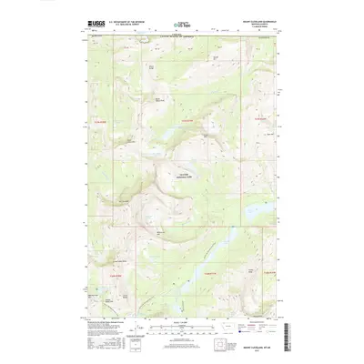
2017 Map of Mount Cleveland
USGS Topo · Published 2017About this map
Glacier National Park straddles the international boundary between Montana and Canada, dominated by the peaks of the Wilson Range and Lewis Range. This high-altitude wilderness is defined by the massive presence of Mt Cleveland, rising above a landscape carved by moving ice. Permanent ice fields like Miche Wabun Glacier and Whitecrow Glacier feed a network of alpine lakes and streams, including Whitecrow Lake and the Mokowanis River. The topography is interconnected by high-country routes such as the Pacific NW National Scenic Trail, which traverses the terrain near Stoney Indian Pass. This survey documents a dynamic glacial environment where water transitions from frozen heights to dramatic drops, evidenced by White Quiver Falls and the Mokowanis Cascade. The map also captures the stark boundary line separating the United States of America from the rugged terrain of Alberta.
Find a feature on this map
54 named features on this map. Tap any name to fly to it.
Don’t see what you’re looking for? This feature index may not catch every label — zoom into the map to look around manually.
Map Details
Editions of this 2017 Mount Cleveland Map
This is the sole edition of this map. No revisions or reprints were ever made.
Other maps of this area

1904 · Chief Mountain
USGS Topo · 1:125,000

1938 · Chief Mountain
USGS Topo · 1:125,000

1960 · Cut Bank
USGS Topo · 1:250,000

1963 · Cut Bank
USGS Topo · 1:250,000

1964 · Cut Bank
USGS Topo · 1:250,000

1968 · Ahern Pass
USGS Topo · 1:24,000

1968 · Gable Mountain
USGS Topo · 1:24,000
1968 · Porcupine Ridge
USGS Topo · 1:24,000
1968 · Mount Cleveland
USGS Topo · 1:24,000
1968 · Mount Geduhn
USGS Topo · 1:24,000