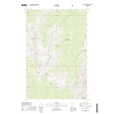
2020 Map of Mount Deception
USGS Topo · Published 2020About this map
Mount Deception and the surrounding high country of the Olympic Peninsula are documented here in detail, showcasing the glaciated peaks and alpine basins that span the Clallam and Jefferson County line. The map highlights the primitive infrastructure of Olympic National Park and the adjacent Olympic National Forest, where drainage systems like the Dosewallips River and Dungeness River carve deep valleys into the landscape. Hikers and researchers can trace the modern routes of the Pacific NW National Scenic Trail as it navigates between prominent landmarks such as Gray Wolf Ridge and Mount Constance. This 2020 survey illustrates a wilderness defined by its verticality, from the subalpine Sunnybrook Meadows to the high-elevation waters of Lake Constance and Royal Lake. The collection of peaks, including The Needles and Hal Foss Peak, provides a comprehensive look at the interior topography of the Olympics in the early twenty-first century.
Find a feature on this map
50 named features on this map. Tap any name to fly to it.
Don’t see what you’re looking for? This feature index may not catch every label — zoom into the map to look around manually.
Map Details
Editions of this 2020 Mount Deception Map
This is the sole edition of this map. No revisions or reprints were ever made.
Other maps of this area

1938 · Mt Constance
USGS Topo · 1:125,000

1944 · Mt. Angeles
USGS Topo · 1:62,500

1946 · Mt. Angeles
USGS Topo · 1:62,500

1946 · Tyler Peak
USGS Topo · 1:62,500

1947 · The Brothers
USGS Topo · 1:62,500

1947 · Mt. Steel
USGS Topo · 1:62,500

1948 · Tyler Peak
USGS Topo · 1:62,500

1950 · The Brothers
USGS Topo · 1:62,500

1950 · Mt. Steel
USGS Topo · 1:62,500

1958 · Seattle
USGS Topo · 1:250,000