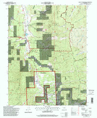
1994 Map of Mount Deception
USGS Topo · Published 1998About this map
Woodland Park anchors the southern boundary of this high-country landscape, where the Rampart Range rises sharply to the east. The area is defined by the extensive research and conservation lands of the Manitou Experimental Forest, including its Headquarters and the nearby Manitou Park Grange. A network of gulches—including Johns Gulch, Lovell Gulch, and Missouri Gulch—drains the eastern slopes of the Divide toward the Manitou Park Lake basin.
Find a feature on this map
47 named features on this map. Tap any name to fly to it.
Don’t see what you’re looking for? This feature index may not catch every label — zoom into the map to look around manually.
Map Details
Editions of this 1994 Mount Deception Map
This is the sole edition of this map. No revisions or reprints were ever made.
Other maps of this area

1893 · Platte Canyon
USGS Topo · 1:125,000

1893 · Colorado Springs
USGS Topo · 1:125,000

1894 · Pikes Peak
USGS Topo · 1:125,000

1894 · Castle Rock
USGS Topo · 1:125,000

1901 · Pikes Peak
USGS Topo · 1:125,000

1901 · Pikes Peak
USGS Topo · 1:62,500

1909 · Colorado Springs
USGS Topo · 1:125,000

1913 · Castle Rock
USGS Topo · 1:125,000

1942 · Colorado Springs
USGS Topo · 1:125,000

1948 · Colorado Springs
USGS Topo · 1:62,500