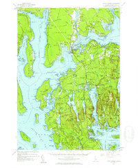
1956 Map of Mount Desert
USGS Topo · Published 1960About this map
Acadia National Park dominates the eastern half of this mid-century coastal survey, showcasing the complex maritime geography of Mount Desert Island and its mainland neighbors. The landscape is defined by the deep indentation of Somes Sound and the broad waters of Union River Bay, which separate the island from the towns of Surry and Trenton. Local life is anchored in historic centers like Somesville and Center, while the inclusion of the Bar Harbor Airport and a Drive-in Theater signals the region's evolving infrastructure. Industry and preservation coexist here, evidenced by numerous quarries near Hall Quarry and the protected lands of Lamoine State Park. For the genealogist or local historian, the map preserves the exact locations of country schools like McFarland Sch and several small family-named burying grounds, including Haynes Cem and Leland Cem.
Find a feature on this map
289 named features on this map. Tap any name to fly to it.
Don’t see what you’re looking for? This feature index may not catch every label — zoom into the map to look around manually.
Map Details
Editions of this 1956 Mount Desert Map
4 editions found

Other maps of this area

1900 · Orland
USGS Topo · 1:62,500

1904 · Deer Isle
USGS Topo · 1:62,500

1904 · Mount Desert
USGS Topo · 1:62,500

1904 · Swan Island
USGS Topo · 1:62,500

1904 · Bar Harbor
USGS Topo · 1:62,500

1904 · Bluehill
USGS Topo · 1:62,500

1905 · Penobscot Bay
USGS Topo · 1:125,000

1911 · Ellsworth
USGS Topo · 1:62,500

1930 · Tunk Lake
USGS Topo · 1:48,000

1932 · Tunk Lake
USGS Topo · 1:62,500