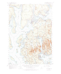
1956 Map of Mount Desert
USGS Topo · Published 1966About this map
Acadia National Park dominates the eastern half of this mid-century survey, showcasing the island's complex network of summits including Sargent Mountain and Penobscot Mountain. The landscape is a mix of rugged coastal terrain and essential transportation infrastructure, such as the Bar Harbor Airport located in Trenton. Coastal life is evidenced by numerous coves and points, with established communities like Southwest Harbor, Somesville, and West Tremont serving as local hubs.
Find a feature on this map
263 named features on this map. Tap any name to fly to it.
Don’t see what you’re looking for? This feature index may not catch every label — zoom into the map to look around manually.
Map Details
Editions of this 1956 Mount Desert Map
4 editions found

Other maps of this area

1900 · Orland
USGS Topo · 1:62,500

1904 · Deer Isle
USGS Topo · 1:62,500

1904 · Mount Desert
USGS Topo · 1:62,500

1904 · Swan Island
USGS Topo · 1:62,500

1904 · Bar Harbor
USGS Topo · 1:62,500

1904 · Bluehill
USGS Topo · 1:62,500

1905 · Penobscot Bay
USGS Topo · 1:125,000

1911 · Ellsworth
USGS Topo · 1:62,500

1930 · Tunk Lake
USGS Topo · 1:48,000

1932 · Tunk Lake
USGS Topo · 1:62,500