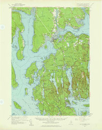
1956 Map of Mount Desert
USGS Topo · Published 1980About this map
Mount Desert Island and its surrounding coastal peninsulas are captured here in a mid-century period of established maritime life and burgeoning conservation. The map highlights the core of Acadia National Park, with its mountain peaks like Mansell Mtn and Acadia Mtn framing the deep waters of Somes Sound. The seafaring heritage of the area is evident in the numerous small harbors and coves, from the active waterfronts of Southwest Harbor and Northeast Harbor to the quieter settlements of Salsbury Cove and Pretty Marsh.
Find a feature on this map
316 named features on this map. Tap any name to fly to it.
Don’t see what you’re looking for? This feature index may not catch every label — zoom into the map to look around manually.
Map Details
Editions of this 1956 Mount Desert Map
4 editions found

Other maps of this area

1900 · Orland
USGS Topo · 1:62,500

1904 · Deer Isle
USGS Topo · 1:62,500

1904 · Mount Desert
USGS Topo · 1:62,500

1904 · Swan Island
USGS Topo · 1:62,500

1904 · Bar Harbor
USGS Topo · 1:62,500

1904 · Bluehill
USGS Topo · 1:62,500

1905 · Penobscot Bay
USGS Topo · 1:125,000

1911 · Ellsworth
USGS Topo · 1:62,500

1930 · Tunk Lake
USGS Topo · 1:48,000

1932 · Tunk Lake
USGS Topo · 1:62,500