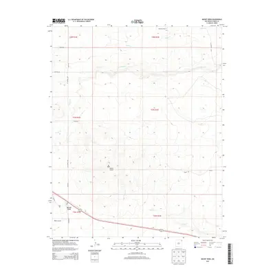
2013 Map of Mount Dora
USGS Topo · Published 2013About this map
Mount Dora and its namesake volcanic peak, Mt Dora, define this high plains landscape in northeastern New Mexico. This 2013 survey illustrates a classic rangeland economy, where wide-reaching cattle operations like the Price Ranch are supported by vital water sources such as Alamos Cr and Seneca Cr. The southern portion of the map is dominated by the topography of Apache Canyon, where Apache Cr cuts through the terrain. Evidence of rural infrastructure is found in family-named routes like Wiseman Rd and Kimbell Rd, alongside more remote landmarks like the McDonald Windmill. The map captures the quiet resilience of Union County, where the settlement at Mount Dora remains a lonely outpost near the deep cleft of Black Canyon, preserving a snapshot of modern ranching life atop ancient geology.
Find a feature on this map
24 named features on this map. Tap any name to fly to it.
Don’t see what you’re looking for? This feature index may not catch every label — zoom into the map to look around manually.
Map Details
Editions of this 2013 Mount Dora Map
This is the sole edition of this map. No revisions or reprints were ever made.
Other maps of this area

1954 · Dalhart
USGS Topo · 1:250,000

1958 · Dalhart
USGS Topo · 1:250,000

1962 · Dalhart
USGS Topo · 1:250,000

1966 · Royce
USGS Topo · 1:24,000

1966 · Black Canyon
USGS Topo · 1:24,000

1972 · Mc Laughlin Bridge
USGS Topo · 1:24,000

1972 · Mount Dora
USGS Topo · 1:24,000

1972 · Bible Top Butte
USGS Topo · 1:24,000
1972 · Boiler Gap
USGS Topo · 1:24,000

1973 · Snyder Lake
USGS Topo · 1:24,000