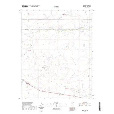
2023 Map of Mount Dora
USGS Topo · Published 2023About this map
Mount Dora serves as the primary focal point of this high-plains landscape in Union County, where the topography is defined by significant volcanic and water-carved features. The prominent volcanic cone of Mount Dora rises above the surrounding terrain, overlooking a network of drainages including Alamos Creek and Seneca Creek to the north, and the deeper incisions of Apache Canyon and Apache Creek to the south. This modern survey reflects the enduring rural infrastructure of northeastern New Mexico, where long-established range roads like Sand Mesa Rd and Weese Rd follow the section lines of the Public Land Survey System. The area around the settlement is characterized by its volcanic geology and the semi-arid watercourses that have shaped the local ranching history. Researchers can observe how contemporary landmarks like Loop Rd and Royce Rd integrate with the ancient landforms of the volcanic field.
Find a feature on this map
23 named features on this map. Tap any name to fly to it.
Don’t see what you’re looking for? This feature index may not catch every label — zoom into the map to look around manually.
Map Details
Editions of this 2023 Mount Dora Map
This is the sole edition of this map. No revisions or reprints were ever made.
Other maps of this area

1954 · Dalhart
USGS Topo · 1:250,000

1958 · Dalhart
USGS Topo · 1:250,000

1962 · Dalhart
USGS Topo · 1:250,000

1966 · Royce
USGS Topo · 1:24,000

1966 · Black Canyon
USGS Topo · 1:24,000

1972 · Mc Laughlin Bridge
USGS Topo · 1:24,000

1972 · Mount Dora
USGS Topo · 1:24,000

1972 · Bible Top Butte
USGS Topo · 1:24,000
1972 · Boiler Gap
USGS Topo · 1:24,000

1973 · Snyder Lake
USGS Topo · 1:24,000