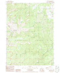
1986 Map of Mount Eddy
USGS Topo · Published 1986About this map
Mount Eddy and the surrounding Eddy Mountains dominate this high-elevation terrain within the Shasta National Forest. The landscape is defined by the headwaters of several major California waterways, including the North Fork, Middle Fork, and South Fork of the Sacramento River, alongside the early course of the Shasta River. This 1986 survey documents a complex hydrological system of alpine lakes and mid-century water management, including the Wood Diversion Dam and a Concrete Diversion Dam located near Morgan Meadows. The boundary between Siskiyou and Trinity counties runs directly through the western ridges, separating high-altitude features like Deadfall Lakes and Toad Lake from the eastern drainage basins. Dozens of 4WD trails and forest service roads crisscross the slopes, reflecting the mid-1980s infrastructure for recreation and resource management in this remote section of the Klamath Mountains.
Find a feature on this map
25 named features on this map. Tap any name to fly to it.
Don’t see what you’re looking for? This feature index may not catch every label — zoom into the map to look around manually.
Map Details
Editions of this 1986 Mount Eddy Map
This is the sole edition of this map. No revisions or reprints were ever made.
Other maps of this area

1886 · Shasta
USGS Topo · 1:250,000

1894 · Shasta
USGS Topo · 1:250,000

1923 · Sawyers Bar
USGS Topo · 1:125,000

1931 · Etna
USGS Topo · 1:96,000

1934 · Etna
USGS Topo · 1:125,000

1935 · Dunsmuir
USGS Topo · 1:125,000

1948 · Weed
USGS Topo · 1:250,000

1950 · Weed
USGS Topo · 1:250,000

1954 · Weed
USGS Topo · 1:62,500

1954 · Dunsmuir
USGS Topo · 1:62,500