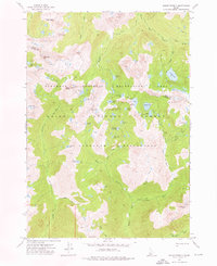
1972 Map of Mount Everly
USGS Topo · Published 1976About this map
Mount Everly stands as the central landmark in this high-altitude landscape within the Sawtooth Wilderness, where the headwaters of major Idaho river systems begin their descent. The terrain is defined by a dense concentration of glacial cirque lakes, including the expansive Tenlake Basin and clustered waters like Spangle Lake, Benedict Lake, and Ardeth Lake. This 1972 field-checked survey illustrates the primitive transportation network of the era, relying entirely on a system of named trails such as the Queens Pack Trail and Mattingly Trails rather than motorized roads. The drainage divide is clearly marked by the separation of the South Fork Payette River to the north and the Middle Fork Boise River to the south. Other prominent summits like Plummer Peak and Glens Peak surround these basins, highlighting the area's role as a protected sanctuary within the Sawtooth National Recreation Area and Boise National Forest.
Find a feature on this map
53 named features on this map. Tap any name to fly to it.
Don’t see what you’re looking for? This feature index may not catch every label — zoom into the map to look around manually.
Map Details
Editions of this 1972 Mount Everly Map
This is the sole edition of this map. No revisions or reprints were ever made.
Other maps of this area

1891 · Bear Valley
USGS Topo · 1:125,000

1893 · Bear Valley
USGS Topo · 1:125,000

1894 · Rocky Bar
USGS Topo · 1:125,000

1900 · Sawtooth
USGS Topo · 1:125,000

1919 · Custer
USGS Topo · 1:125,000

1922 · Custer
USGS Topo · 1:125,000

1955 · Hailey
USGS Topo · 1:250,000

1957 · Challis
USGS Topo · 1:250,000

1959 · Hailey
USGS Topo · 1:250,000

1960 · Challis
USGS Topo · 1:250,000