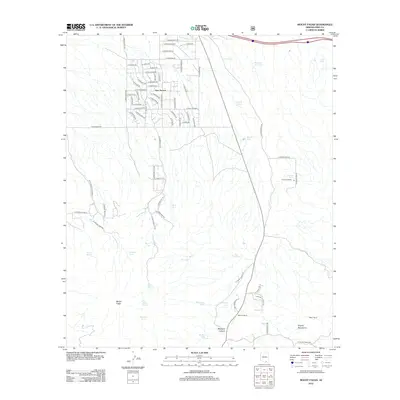
2012 Map of Mount Fagan
USGS Topo · Published 2012About this map
New Tucson stands as a primary residential cluster in the north, showing a dense street network including E Darlene Dr and E Shasta Ln that contrasts sharply with the expansive desert and ranch lands to the south. The landscape is defined by the elevation of Mount Fagan and the Empire Mountains, which drop off into a complex system of washes and canyons like Mulberry Canyon. Water management is central to the history of this arid region, evidenced by the numerous named stock tanks and natural seeps such as Ojo Blanco Spring, Mulberry Spring, and Davidson Spring. Historic land use is traced through established spreads like Andrada Ranch, Martinez Ranch, and Hillton Ranch, connected by rugged trails like E Ghost Dance Rd and E Silverstrike Trl. The presence of Cemetery Tank suggests a proximity to early burial sites, while the modest naming of The Lake highlights the significance of any perennial water source in this Pima County terrain.
Find a feature on this map
83 named features on this map. Tap any name to fly to it.
Don’t see what you’re looking for? This feature index may not catch every label — zoom into the map to look around manually.
Map Details
Editions of this 2012 Mount Fagan Map
This is the sole edition of this map. No revisions or reprints were ever made.
Other maps of this area
1904 · Patagonia
USGS Topo · 1:125,000
1904 · Tucson
USGS Topo · 1:125,000
1905 · Patagonia
USGS Topo · 1:125,000
1905 · Tucson
USGS Topo · 1:125,000
1926 · Helvetia
USGS Topo · 1:62,500
1948 · Tucson
USGS Topo · 1:62,500
1956 · Nogales
USGS Topo · 1:250,000

1956 · Tucson
USGS Topo · 1:250,000
1957 · Tucson
USGS Topo · 1:62,500
1957 · Rincon Valley
USGS Topo · 1:62,500