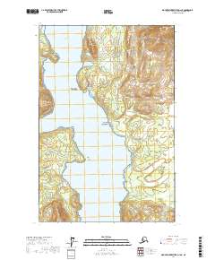
2017 Map of Mount Fairweather D-1 NE
USGS Topo · Published 2017About this map
Glacier Bay National Park dominates this coastal survey, where the advancing and receding patterns of glacial activity have carved a complex network of waterways and high-elevation landforms. The central corridor of Muir Inlet serves as the primary focal point, flanked by prominent coastal markers like Westdahl Point and Rowlee Point. The terrain is characterized by dramatic elevation shifts, rising from the waters of Glacier Bay to the heights of Red Mtn and the isolated rise of The Nunatak. These features provide a clear picture of the region's geological transition, as ice-carved valleys and sheltered inlets like Hunter Cove and Stump Cove define the shoreline. Small topographic details, including the Klotz Hills and Sealers Island, offer specific points of reference for researchers studying the shifting coastline within this protected Alaskan wilderness.
Find a feature on this map
18 named features on this map. Tap any name to fly to it.
Don’t see what you’re looking for? This feature index may not catch every label — zoom into the map to look around manually.
Map Details
Editions of this 2017 Mount Fairweather D-1 NE Map
This is the sole edition of this map. No revisions or reprints were ever made.
Other maps of this area

1948 · Mount Fairweather D-1
USGS Topo · 1:63,360

1949 · Juneau D-6
USGS Topo · 1:63,360

1951 · Juneau
USGS Topo · 1:250,000

1951 · Mt Fairweather
USGS Topo · 1:250,000

1952 · Skagway
USGS Topo · 1:250,000

1954 · Mount Fairweather D-1
USGS Topo · 1:63,360

1954 · Skagway A-3
USGS Topo · 1:63,360
1961 · Skagway A-4
USGS Topo · 1:63,360

1961 · Mt Fairweather
USGS Topo · 1:250,000

1961 · Skagway
USGS Topo · 1:250,000