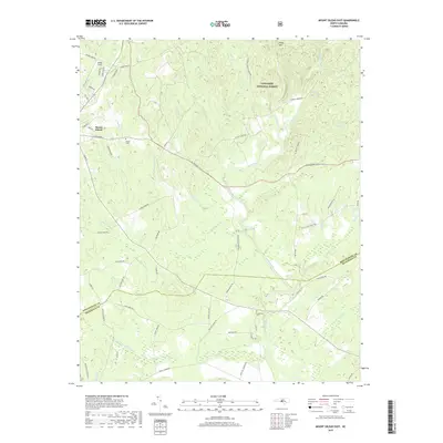
2019 Map of Mount Gilead East
USGS Topo · Published 2019About this map
Uwharrie National Forest dominates the northeastern landscape of this map, where the terrain rises toward Piney Mtn amidst a complex network of tributaries. The settlement of Mount Gilead anchors the western edge, serving as a gateway to the diverse waterways that define the region. The Little River winds through the central portion of the sheet, joined by numerous creeks including Big Town Cr, Little Town Cr, and Susies Cr. Traces of local history are preserved in the locations of Sharon Cem and Ledbetter Cem, while Jordan Field and Airstrip Rd indicate small-scale aviation activity. The border between Montgomery Co and Richmond Co cuts across the southern reach, a rural area characterized by long-established family farm roads like Hearne Farm Rd and Gaddy Farm Rd.
Find a feature on this map
74 named features on this map. Tap any name to fly to it.
Don’t see what you’re looking for? This feature index may not catch every label — zoom into the map to look around manually.
Map Details
Editions of this 2019 Mount Gilead East Map
This is the sole edition of this map. No revisions or reprints were ever made.
Other maps of this area

1942 · Troy
USGS Topo · 1:125,000

1953 · Raleigh
USGS Topo · 1:250,000

1953 · Charlotte
USGS Topo · 1:250,000

1954 · Charlotte
USGS Topo · 1:250,000

1954 · Raleigh
USGS Topo · 1:250,000

1956 · Mangum
USGS Topo · 1:24,000

1956 · Mount Gilead East
USGS Topo · 1:24,000

1956 · Ellerbe
USGS Topo · 1:24,000

1956 · Harrisville
USGS Topo · 1:24,000

1956 · Ansonville
USGS Topo · 1:24,000