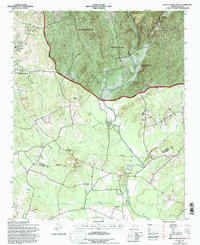
1994 Map of Mount Gilead East
USGS Topo · Published 1996About this map
Town Creek Indian Mound State Park highlights the landscape along the Little River at the southern edge of the Uwharrie National Forest. The geography is defined by a dense network of watercourses, including Town Creek, Big Creek, and Hamer Creek, which cut through the terrain toward the Montgomery and Richmond county line. In the west, the community of Mount Gilead is positioned along the Norfolk Southern railroad, while the eastern portion of the sheet features the historic location of Littles Mill. The area's social fabric is visible through numerous rural landmarks like Pee Dee Ch, Mountain Grove Ch, and Snow Hill Church, alongside family-named sites such as Ledbetter Cem. The distribution of these churches and cemeteries suggests long-established agricultural settlements clustered near the river branches.
Find a feature on this map
31 named features on this map. Tap any name to fly to it.
Don’t see what you’re looking for? This feature index may not catch every label — zoom into the map to look around manually.
Map Details
Editions of this 1994 Mount Gilead East Map
This is the sole edition of this map. No revisions or reprints were ever made.
Other maps of this area

1942 · Troy
USGS Topo · 1:125,000

1953 · Raleigh
USGS Topo · 1:250,000

1953 · Charlotte
USGS Topo · 1:250,000

1954 · Charlotte
USGS Topo · 1:250,000

1954 · Raleigh
USGS Topo · 1:250,000

1956 · Mangum
USGS Topo · 1:24,000

1956 · Mount Gilead East
USGS Topo · 1:24,000

1956 · Ellerbe
USGS Topo · 1:24,000

1956 · Harrisville
USGS Topo · 1:24,000

1956 · Ansonville
USGS Topo · 1:24,000