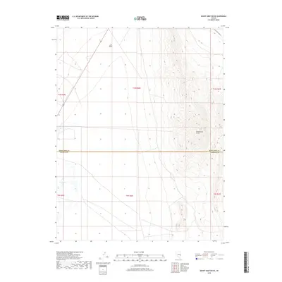
2018 Map of Mount Grafton NE
USGS Topo · Published 2018About this map
The Fortification Range dominates the eastern half of this terrain, where steep-banked ridges rise sharply above the flat expanse of Lake Valley. This 2018 survey captures the hydrologic character of the Great Basin, where seasonal or perennial water sources like Travis Reservoir and the descriptively named Freshwater Lake provide critical points of interest in an otherwise arid landscape. The map serves as a detailed record of the borderlands between White Pine and Lincoln counties, showing how modern infrastructure such as White Pine Co Road 47 skirts the high ground to connect the northern reaches of the valley.
Find a feature on this map
12 named features on this map. Tap any name to fly to it.
Don’t see what you’re looking for? This feature index may not catch every label — zoom into the map to look around manually.
Map Details
Editions of this 2018 Mount Grafton NE Map
This is the sole edition of this map. No revisions or reprints were ever made.
Other maps of this area

1948 · Wheeler Peak
USGS Topo · 1:62,500

1950 · Wheeler Peak
USGS Topo · 1:62,500

1956 · Lund
USGS Topo · 1:250,000

1960 · Lund
USGS Topo · 1:250,000

1973 · Gouge Eye Well
USGS Topo · 1:24,000

1973 · Indian Springs Knolls
USGS Topo · 1:24,000

1973 · Cattle Camp Spring
USGS Topo · 1:24,000
1973 · Mount Grafton NE
USGS Topo · 1:24,000
1978 · Mt. Grafton
USGS Topo · 1:24,000
1978 · The Gouge Eye
USGS Topo · 1:24,000