
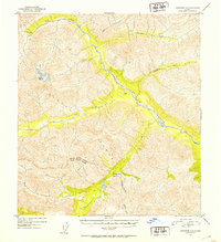
1954 Map of Mount Hayes B-1
USGS Topo · Published 1954About this map
Robertson Glacier dominates the southwestern corner of this 1954 topographic study, serving as the source for a complex glacial drainage system. The meltwater feeds into the braided channels of the West Fork Robertson River, which winds through steep, unpopulated mountain passes before joining the main Robertson River. This remote Alaskan landscape is characterized by its high-altitude glacial activity and the absence of any established trails or roads at the time of the survey. The mapping relies on 1954 aerial photography to trace the intricate paths of Rumble Creek and various unnamed glacial pools that collect in the high basins. The map illustrates a pure wilderness environment where the physical geography—defined by ice and moving water—remains the only landmark.
Find a feature on this map
4 named features on this map. Tap any name to fly to it.
Don’t see what you’re looking for? This feature index may not catch every label — zoom into the map to look around manually.
Map Details
Editions of this 1954 Mount Hayes B-1 Map
This is the sole edition of this map. No revisions or reprints were ever made.
Other maps of this area

1948 · Tanacross A-6
USGS Topo · 1:63,360

1949 · Tanacross
USGS Topo · 1:250,000

1949 · Tanacross B-6
USGS Topo · 1:63,360

1949 · Mt. Hayes A-1
USGS Topo · 1:63,360

1950 · Tanacross
USGS Topo · 1:250,000

1950 · Mount Hayes
USGS Topo · 1:250,000

1951 · Mount Hayes
USGS Topo · 1:250,000

1951 · Tanacross B-6
USGS Topo · 1:63,360
1952 · Tanacross A-6
USGS Topo · 1:63,360

1954 · Tanacross C-6
USGS Topo · 1:63,360