
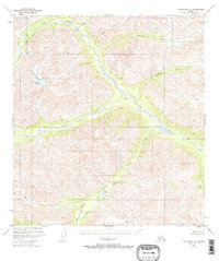
1948 Map of Tanacross A-6
USGS Topo · Published 1965About this map
The Tok River and its expansive network of tributaries dominate this interior Alaskan landscape, as documented through aerial photography in the late 1940s. The terrain is characterized by a central drainage system where the river meets Dry Creek and Timber Creek, creating a critical corridor through the high country. An isolated Cabin provides evidence of human presence in this remote wilderness, likely serving as a waypoint for travelers or trappers. To the south, Sikonsina Pass serves as a natural gateway, flanked by Burnt Lake and the headwaters of Bone Creek. Several creeks named for minerals or local terminology, such as Stibnite Creek and Shindata Creek, suggest a landscape defined by its geology and early prospecting history. The absence of roads underscores the reliance on river valleys and mountain passes for movement throughout the Tanacross region.
Find a feature on this map
12 named features on this map. Tap any name to fly to it.
Don’t see what you’re looking for? This feature index may not catch every label — zoom into the map to look around manually.
Map Details
Editions of this 1948 Tanacross A-6 Map
2 editions found
Other maps of this area

1948 · Tanacross B-5
USGS Topo · 1:63,360

1948 · Nabesna D-5
USGS Topo · 1:63,360

1948 · Tanacross A-5
USGS Topo · 1:63,360

1949 · Tanacross
USGS Topo · 1:250,000

1949 · Nabesna D-6
USGS Topo · 1:63,360

1949 · Tanacross A-5
USGS Topo · 1:63,360

1949 · Tanacross B-6
USGS Topo · 1:63,360

1949 · Mt. Hayes A-1
USGS Topo · 1:63,360

1950 · Tanacross
USGS Topo · 1:250,000

1950 · Nabesna
USGS Topo · 1:250,000