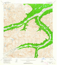
1955 Map of Mount Hayes B-1
USGS Topo · Published 1963About this map
The Robertson Glacier dominates the southwestern corner of this mid-century topographic study, serving as the massive icy headwater for the braided drainage systems that define this part of the Alaska Range. As the glacier recedes, it feeds the wide, gravel-choked channels of the Robertson River, which arcs through the northeastern reaches of the map. This era of surveying, based on 1954 aerial photography, captures a raw landscape of high-elevation peaks and glacial valleys entirely devoid of human infrastructure. The drainage network is further shaped by the West Fork and the smaller Rumble Creek, illustrating the complex hydrology of a subarctic environment where water and ice are the primary architects of the land. The lack of roads or trails highlights the transition of the region from unexplored wilderness to a systematically mapped territory under the administration of the Bureau of Land Management.
Find a feature on this map
4 named features on this map. Tap any name to fly to it.
Don’t see what you’re looking for? This feature index may not catch every label — zoom into the map to look around manually.
Map Details
Editions of this 1955 Mount Hayes B-1 Map
2 editions found
Other maps of this area

1948 · Tanacross A-6
USGS Topo · 1:63,360

1949 · Tanacross
USGS Topo · 1:250,000

1949 · Tanacross B-6
USGS Topo · 1:63,360

1949 · Mt. Hayes A-1
USGS Topo · 1:63,360

1950 · Tanacross
USGS Topo · 1:250,000

1950 · Mount Hayes
USGS Topo · 1:250,000

1951 · Mount Hayes
USGS Topo · 1:250,000

1951 · Tanacross B-6
USGS Topo · 1:63,360
1952 · Tanacross A-6
USGS Topo · 1:63,360

1954 · Mount Hayes B-1
USGS Topo · 1:63,360