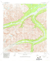
1955 Map of Mount Hayes B-1
USGS Topo · Published 1983About this map
Robertson Glacier dominates the southwestern corner of this interior Alaskan landscape, feeding into a complex network of braided river channels and alpine drainage. The terrain is characterized by the massive glacial tongue and the expansive West Fork Robertson River, which carves a wide valley floor through the high mountain peaks. Aerial photography from the mid-1950s captured this remote wilderness at a time when mapping efforts focused on the immense topographical relief of the eastern Alaska Range. Small alpine features like Monte Lake and the tributary Rumble Creek provide key reference points within the steep contours, illustrating the glacial hydrology of the Robertson River watershed before later twentieth-century environmental shifts.
Find a feature on this map
4 named features on this map. Tap any name to fly to it.
Don’t see what you’re looking for? This feature index may not catch every label — zoom into the map to look around manually.
Map Details
Editions of this 1955 Mount Hayes B-1 Map
2 editions found
Other maps of this area

1948 · Tanacross A-6
USGS Topo · 1:63,360

1949 · Tanacross
USGS Topo · 1:250,000

1949 · Tanacross B-6
USGS Topo · 1:63,360

1949 · Mt. Hayes A-1
USGS Topo · 1:63,360

1950 · Tanacross
USGS Topo · 1:250,000

1950 · Mount Hayes
USGS Topo · 1:250,000

1951 · Mount Hayes
USGS Topo · 1:250,000

1951 · Tanacross B-6
USGS Topo · 1:63,360
1952 · Tanacross A-6
USGS Topo · 1:63,360

1954 · Mount Hayes B-1
USGS Topo · 1:63,360