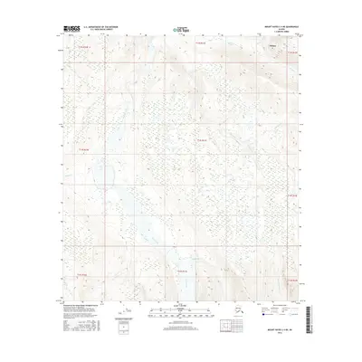
2016 Map of Mount Hayes C-4 NE
USGS Topo · Published 2016About this map
Deltana sits in the northeast corner of this interior Alaskan landscape, overlooking a complex network of glacial outwash and braided watercourses. The broad, shifting path of Jarvis Creek dominates the central and southern terrain, its wide gravel bars typical of the region's high-energy alpine drainages. To the east, several smaller tributaries such as McCumber Cr and Morningstar Cr flow from higher elevations toward the main channel. This 2016 survey illustrates a largely unpopulated wilderness defined by dynamic hydrology, where features like Old Channel Cr indicate the historical movement of water across the alluvial plain. Further west, the terrain rises steadily beyond Sargent Cr, while southern reaches are defined by the headwaters of Riley Creek and Little Gold Cr.
Find a feature on this map
20 named features on this map. Tap any name to fly to it.
Don’t see what you’re looking for? This feature index may not catch every label — zoom into the map to look around manually.
Map Details
Editions of this 2016 Mount Hayes C-4 NE Map
This is the sole edition of this map. No revisions or reprints were ever made.
Other maps of this area

1950 · Mount Hayes
USGS Topo · 1:250,000

1950 · Mount Hayes D-4
USGS Topo · 1:63,360

1950 · Mount Hayes C-4
USGS Topo · 1:63,360

1951 · Mount Hayes
USGS Topo · 1:250,000

1952 · Mount Hayes D-4
USGS Topo · 1:63,360

1952 · Mount Hayes C-4
USGS Topo · 1:63,360

1954 · Mount Hayes C-3
USGS Topo · 1:63,360

1954 · Mount Hayes D-3
USGS Topo · 1:63,360
1955 · Mount Hayes D-3
USGS Topo · 1:63,360

1955 · Mount Hayes C-3
USGS Topo · 1:63,360