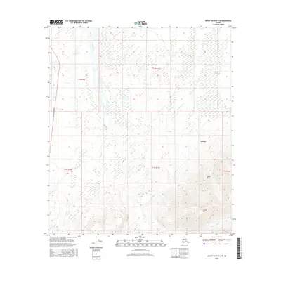
2016 Map of Mount Hayes D-4 SE
USGS Topo · Published 2016About this map
The Alaska Range foothills dominate this interior landscape, where the high peak of Granite Mtn rises above the glacial drainages of the Unorganized Borough. The terrain is defined by the significant braided watercourse of Jarvis Creek and its various tributaries, including Ober Cr and Granite Cr, which cut through the complex topography of the Delta River valley. These waterways carry the meltwater from the high peaks south of the settlement at Deltana. Along the western edge of the quadrangle, the Richardson Highway provides the primary corridor for movement, skirting the edge of the wetlands and lower slopes. This survey provides a look at the intersection of modern infrastructure and the challenging subarctic environment, documenting the drainage patterns of MJ Cr and the surrounding township boundaries in a region where the landforms dictate the limits of human settlement and transport.
Find a feature on this map
14 named features on this map. Tap any name to fly to it.
Don’t see what you’re looking for? This feature index may not catch every label — zoom into the map to look around manually.
Map Details
Editions of this 2016 Mount Hayes D-4 SE Map
This is the sole edition of this map. No revisions or reprints were ever made.
Other maps of this area

1950 · Mount Hayes
USGS Topo · 1:250,000

1950 · Mount Hayes D-4
USGS Topo · 1:63,360

1950 · Mount Hayes C-4
USGS Topo · 1:63,360

1951 · Mount Hayes
USGS Topo · 1:250,000

1952 · Mount Hayes D-4
USGS Topo · 1:63,360

1952 · Mount Hayes C-4
USGS Topo · 1:63,360

1954 · Mount Hayes C-3
USGS Topo · 1:63,360

1954 · Mount Hayes D-3
USGS Topo · 1:63,360
1955 · Mount Hayes D-3
USGS Topo · 1:63,360

1955 · Mount Hayes C-3
USGS Topo · 1:63,360