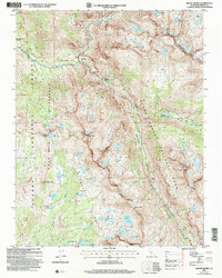
2004 Map of Mount Henry
USGS Topo · Published 2007About this map
Mount Henry stands at the center of this high Sierra landscape, marking the boundary between the Sierra National Forest and Kings Canyon National Park. This 2004 revision details a region defined by glacial geology, where the Glacier Divide and Red Mountain Basin cradle numerous alpine lakes such as the Devils Punchbowl and Disappointment Lake. The John Muir Trail winds through the western half of the map, passing significant landmarks like the John Muir Trail Cabin and John Muir Rock.
Find a feature on this map
52 named features on this map. Tap any name to fly to it.
Don’t see what you’re looking for? This feature index may not catch every label — zoom into the map to look around manually.
Map Details
Editions of this 2004 Mount Henry Map
This is the sole edition of this map. No revisions or reprints were ever made.
Other maps of this area

1912 · Mt. Goddard
USGS Topo · 1:125,000

1947 · Mariposa
USGS Topo · 1:250,000

1948 · Mariposa
USGS Topo · 1:250,000

1948 · Mt. Goddard
USGS Topo · 1:62,500

1949 · Mt. Tom
USGS Topo · 1:62,500

1951 · Mt. Tom
USGS Topo · 1:62,500

1951 · Mt. Goddard
USGS Topo · 1:62,500

1952 · Mt. Goddard
USGS Topo · 1:62,500

1953 · Mt Abbot
USGS Topo · 1:62,500

1953 · Blackcap Mtn
USGS Topo · 1:62,500